Visualização de leitura

Tracking a Sanctioned Russian Vessel’s West African Odyssey

Sign up here to receive Bellingcat’s biggest investigations by email as soon as they are published.

A sanctioned vessel that was previously reported to have transported weapons destined for Russian mercenaries has been traversing ports on the west coast of Africa since March, exhibiting what experts told Bellingcat  was an unusual set of movements and behaviours.

Patria (IMO: 9159921) has been sanctioned by the US, Ukraine and Canada.

Support Bellingcat

Your donations directly contribute to our ability to publish groundbreaking investigations and uncover wrongdoing around the world.

Radio France International (RFI) reported last year that it was one of two ships to deliver weapons to Conakry in Guinea that were intended for the Kremlin-controlled Africa Corps and their operations in Mali.

Satellite imagery and Automated Identification System (AIS) data from Lloyd’s List Intelligence shows Patria has shuttled between the Port of Douala in Cameroon and the Port of Owendo in Libreville, Gabon four times since March. 

It has also twice stopped in anchorage off the coast of Lagos, Nigeria: first in March and then again at the time of publication. Analysis shows the vessel also spent time in anchorage off the coast of Equatorial Guinea. 

The online news site, Modern Ghana, first reported Patria’s presence off the coast of Lagos in July after X-users @SONNAROW_OSINT and @RFNOSBlog picked up on Patria’s position.

It is not clear what Patria has delivered or picked up at these ports. Nor is it clear why it has spent so long going back and forth between them. But experts Bellingcat spoke to said the unusual patterns of behaviour raised numerous questions.

Charlie Brown, a former US Naval Officer and Senior Advisor at United Against Nuclear Iran said the combination of Patria’s repeated regional port calls, extended periods at anchor, and an apparent absence of a normal point-to-point trading cycle warranted scrutiny, especially as the ship is under sanction and is previously reported to have shipped arms. 

Tracking the Patria

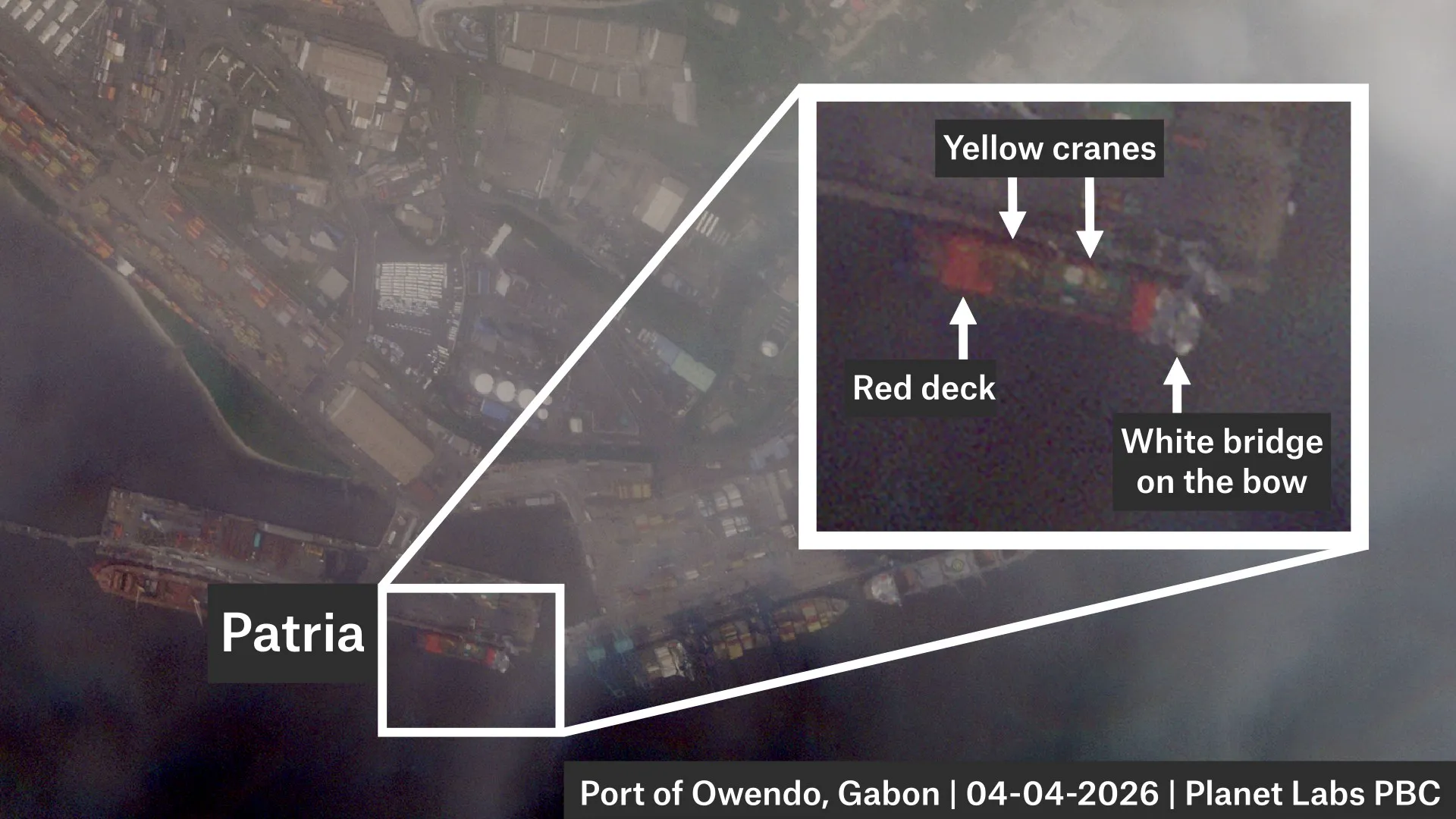
Patria is a cargo vessel that has a distinct shape and features. Its bridge is located on the bow and it has a bright red deck that contrasts with its blue hull and two yellow cranes. 

At the end of the deck, the ship has a built-in ramp for vehicles (the Patria is a so-called roll on/roll off, or RoRo, vessel that is designed to transport wheeled vehicles). Its chimney is located next to the ramp.

Footage of the Patria, posted on Youtube on Jan 22, 2024. Credit: Hanro Shipping – Sakhalin Projects LLC / YouTube Channel @hanroship

This, in combination with the length of the ship (101 m), allowed Bellingcat to pick the vessel out in satellite imagery. AIS data helped us further track its long journey which began in the Sea of Japan, in Russia’s far-east, in January.

For the most part, we were able to match Patria’s AIS position with corresponding satellite imagery. We found no evidence of obvious spoofing incidents (where a ship intentionally broadcasts misleading AIS data) by the vessel during its months-long voyage, however, there were some instances where satellite images were not available and thus spoofing by the vessel cannot be completely ruled out.

MapLibre | Protomaps© OpenStreetMap contributors

Port of Olga, Russia

AIS data indicates that Patria loaded at the Port of Olga in the Sea of Japan between Jan. 21 and 23. Patria can also be seen on satellite imagery on these dates.
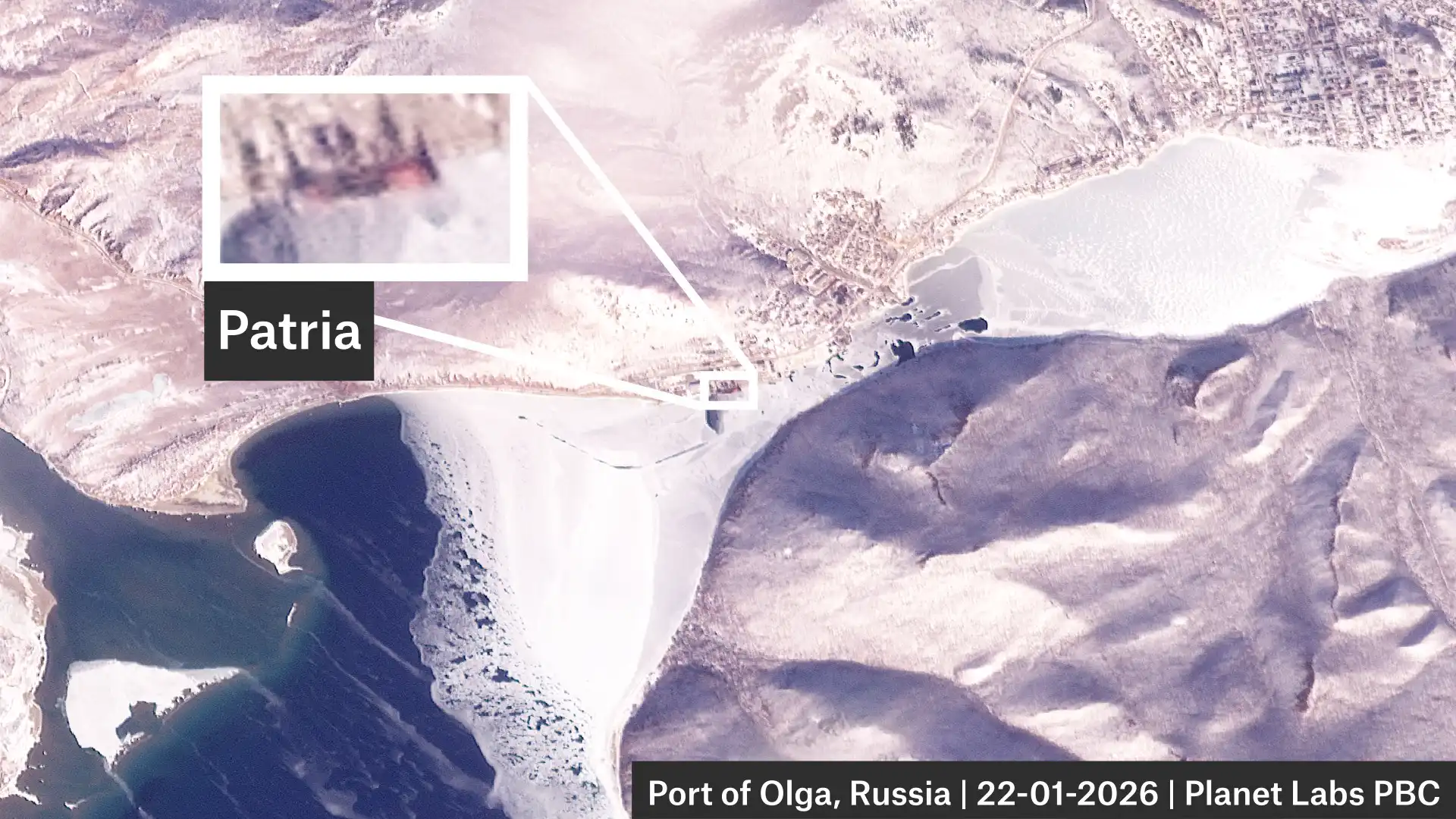
Credit: Planet Labs PBC.

Port of Douala, Cameroon

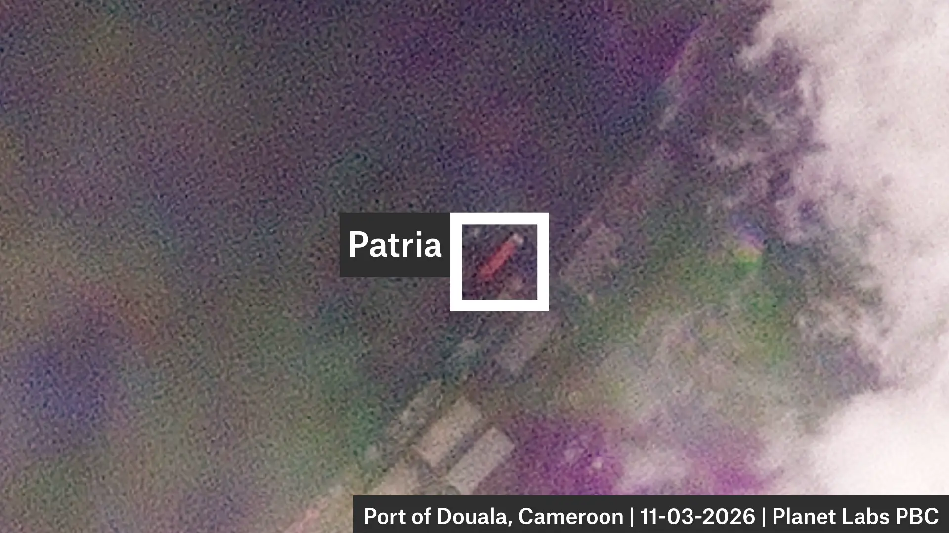
AIS data indicates that Patria unloaded some cargo in the Port of Douala between Mar. 11 and 12. Again, the ship can also be seen in satellite imagery on these dates.
Credit: Planet Labs PBC.

Lagos Anchorage, Nigeria

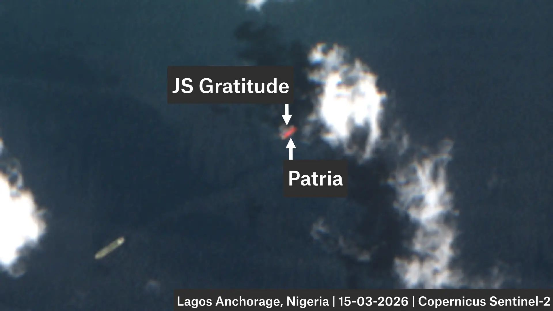
AIS data indicates Patria anchored off the coast of Lagos from Mar. 14 to 15.

A Sentinel-2 image from the 15th appears to show another ship next to Patria. AIS data indicates that this is JS Gratitude, a bunkering tanker. This close proximity suggests that Patria was refuelling.
Credit: Contains modified Copernicus Sentinel data 2026.

Bata Anchorage, Equatorial Guinea

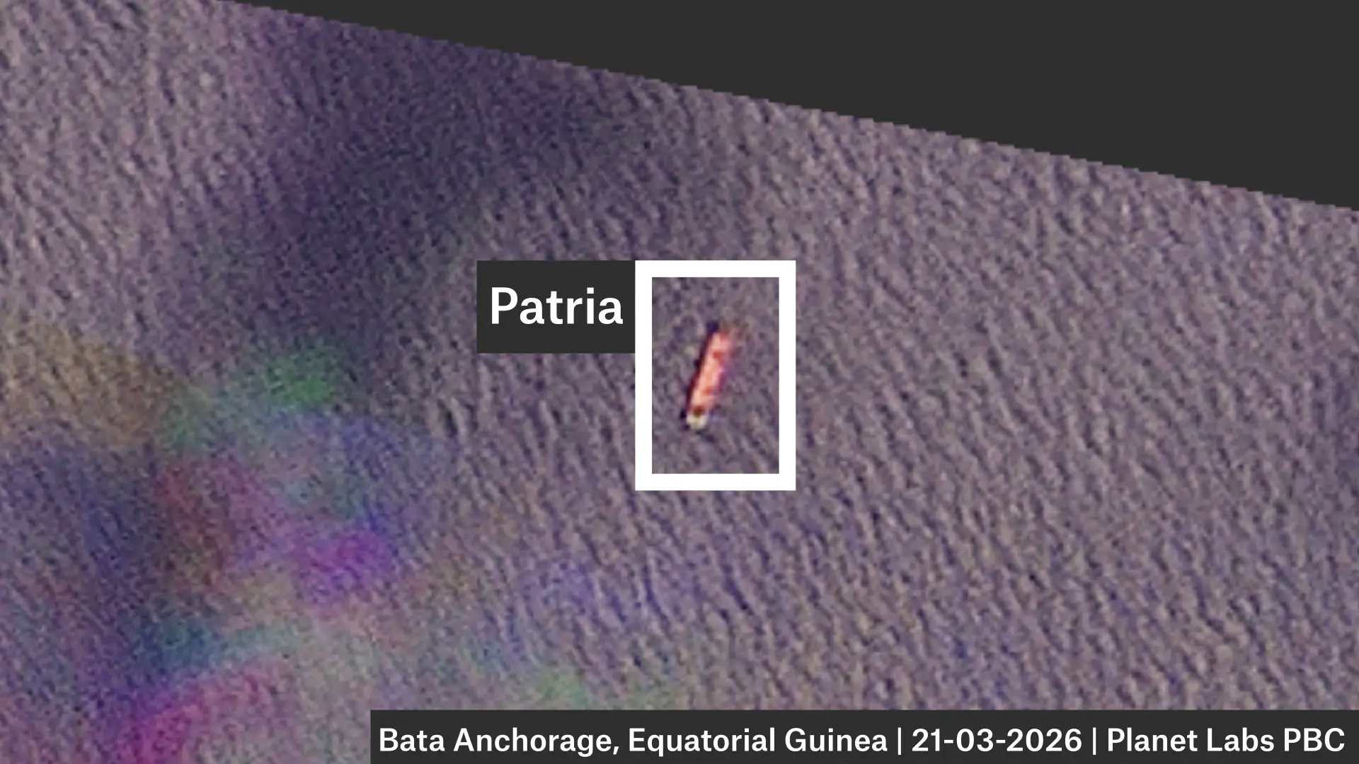
AIS data and satellite imagery indicate Patria stayed off the coast of Equatorial Guinea for several days.
Credit: Planet Labs PBC.

Port of Owendo, Libreville, Gabon

AIS data and satellite imagery indicate Patria loaded at the Port of Owendo in Libreville after spending a few days off the coast.
Credit: Planet Labs PBC.

Port of Douala, Cameroon

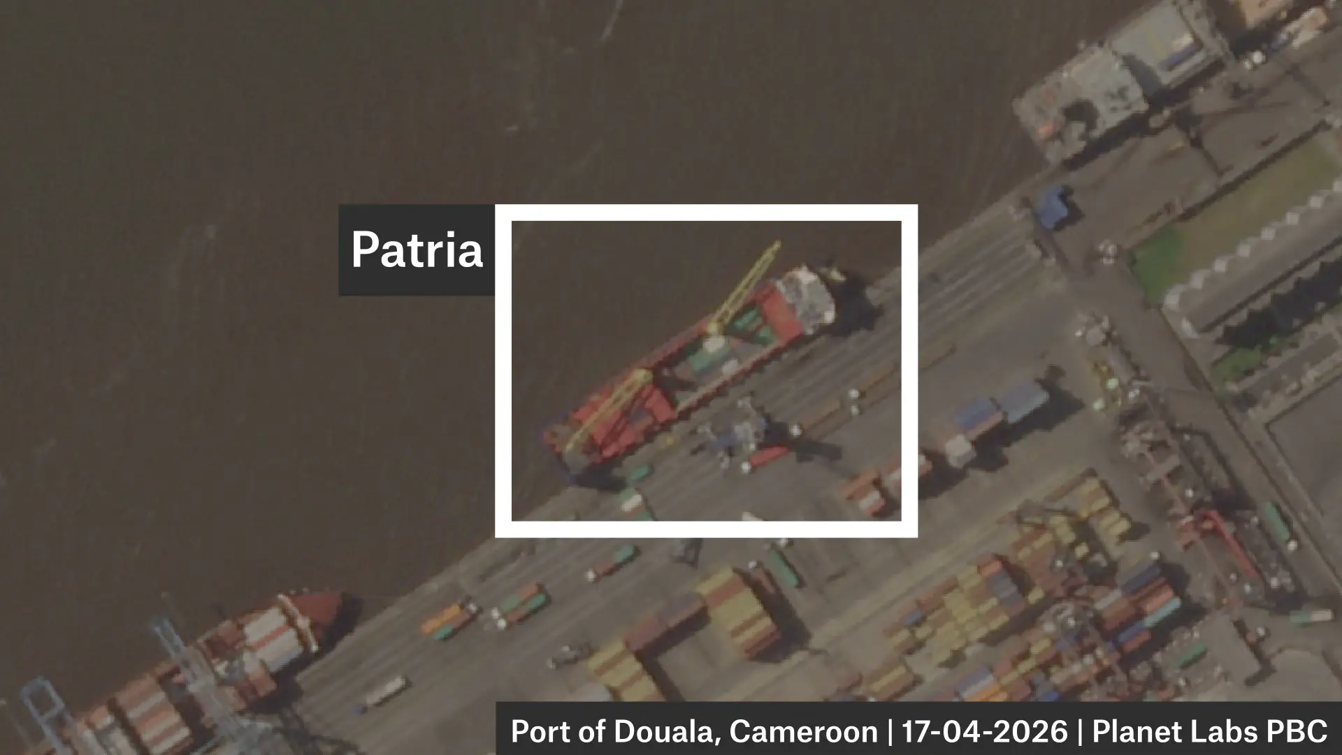
AIS data and satellite imagery indicate Patria stayed at the Douala Anchorage from Apr. 6 to 14, before unloading at the Port of Douala between Apr. 14 and 18.
Credit: Planet Labs PBC.

Port of Owendo, Libreville, Gabon

AIS data suggests Patria loaded in Libreville again between Apr. 22 and 26.

Port of Douala, Cameroon

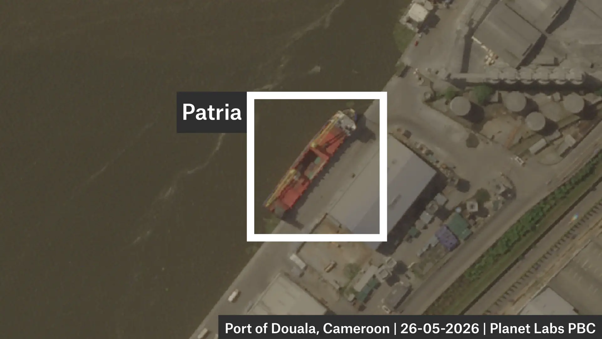
AIS data, supported by satellite imagery, indicates Patria stayed at the Douala Anchorage for nearly a month from Apr. 27 to May 21 before unloading in Douala from May 21 to 27.
Credit: Planet Labs PBC.

A third trip between the Port of Owendo, Libreville to Douala, Cameroon

AIS data indicates, after nearly a month’s wait in Douala anchorage, Patria again loaded at Owendo before returning to Douala to unload.

A fourth trip between the Port of Owendo, Libreville to Douala, Cameroon

AIS data indicates Patria again loaded at Owendo before returning to Douala to unload.

Lagos Anchorage, Nigeria

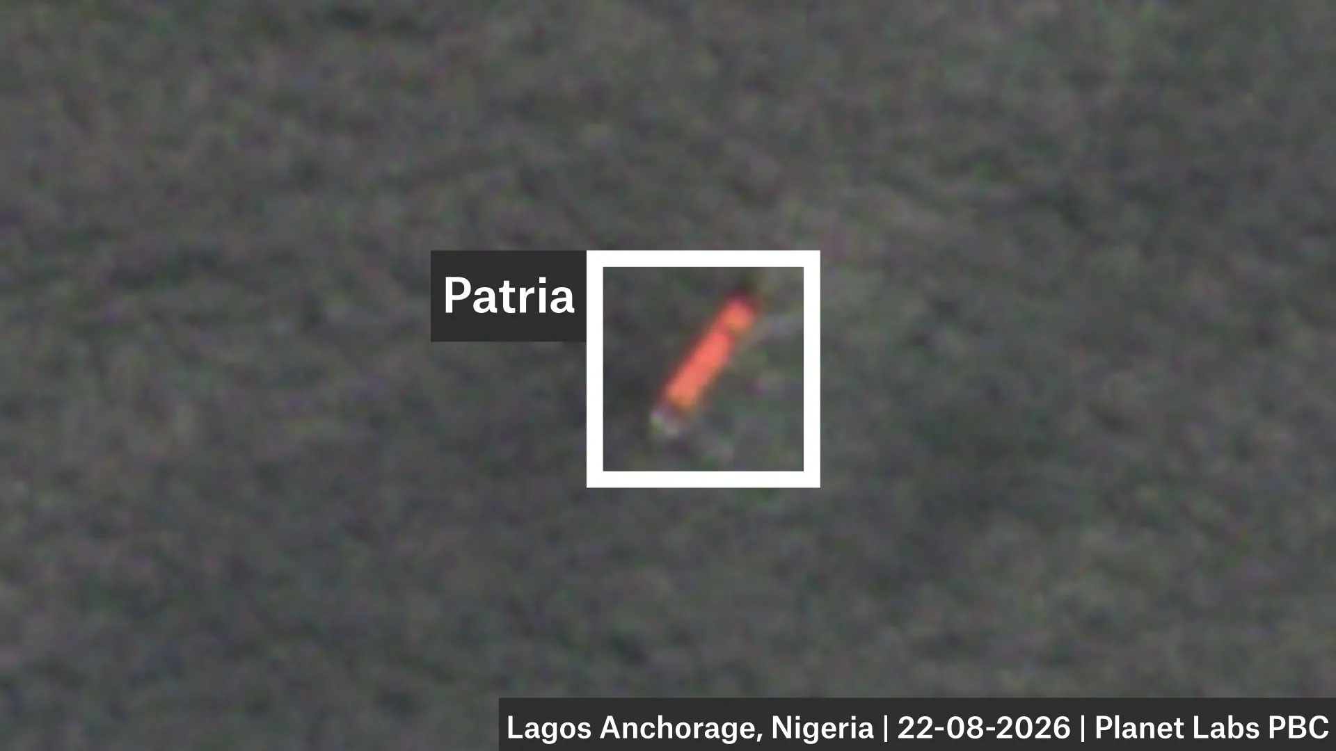
AIS data indicates, after a short visit to the Libreville anchorage, Patria anchored off the coast of Lagos where it remained at the time of publication.
Credit: Planet Labs PBC.

Examining the Patria’s Draught

We reviewed the draught of the ship at each port visit and found that the ship’s draught always dropped after a stay at the Port of Douala, suggesting it was unloading there.

A ship’s “draught” is the distance from the bottom of the hull (the keel) to the waterline. When loaded, a ship is heavier and sits lower in the water (e.g. a draught of six metres) than when it is unloaded (e.g. a draught of four metres).

Draught is the depth of a ship below the waterline. 

In the period from March to July, the Patria made five port calls to Douala and each time the draught decreased. Conversely, it called four times at the Port of Owendo in Libreville, each time the draught increased, meaning the ship became heavier, suggesting it was loading.

The draught is self-reported by ships but usually when it arrives at ports this kind of data is checked – reporting accurate draught is also a safety issue for ships arriving and departing at ports. 

Bellingcat asked the ship’s owners, managers and both ports if items were being transferred from Libreville to Douala but did not receive a response at time of publication.

Brown, the former US Naval Officer and now a Senior Advisor at United Against Nuclear Iran, said Patria’s movements were unusual.

“A sanctioned vessel linked to a prior military logistics shipment spending nearly six months operating between a small cluster of West African ports, Douala, and Owendo, without returning to a clear commercial trading pattern warrants scrutiny,” Brown told us.  


“While innocent explanations such as mechanical issues, commercial disputes, lack of cargo, chartering delays, or prolonged maintenance are possible, the combination of repeated regional port calls, extended periods at anchor, and an apparent absence of a normal point-to-point trading cycle is atypical for a merchant vessel.” 

He added that the current period of more than 30 days at the Lagos Anchorage, in particular, is noteworthy. 

David Soud, Head of Research and Analysis at I.R Consilium also told Bellingcat that Patria’s prolonged Lagos Anchorage could have innocent explanations such as its need for ongoing repairs, or that its operators were out of money, but added that there could also be more calculated reasons and it was laying low for a while.

Bellingcat analysed AIS data from Lagos Anchorage and found that while there has been high congestion, no other RoRo or container vessel waited longer than 10 days to enter the port in the period that Patria has been at Lagos Anchorage. At time of writing, Patria has been in anchorage for more than 30 days.

Regarding the Patria’s apparent deliveries of cargo between Libreville in Gabon, and Douala in Cameroon, Soud told Bellingcat:

“Given the vessel’s history of transporting military equipment to African seaports for overland delivery to Russian and allied forces in the Sahel, it’s not out of the question that some form of supplies for Russian or other forces could be picked up in Gabon, whose government has developed a closer relationship with Moscow, to be discharged in Douala, which is the main entry point for goods going to Central African Republic.”

Bellingcat asked the Nigerian Ports Authority why Patria had been in anchorage for so long, whether it had applied to dock and whether the port was aware of its sanctioned status but did not receive a response at time of publication.

The ports of Douala in Cameroon and Owendo in Libreville, Gabon did not respond to Bellingcat’s requests for comment about the Patria’s visits and the cargo it was carrying.

Bellingcat also contacted the two companies connected to the vessel – Hanro Shipping and Sakhalin Shipping Company which are listed as the vessel’s owner and manager respectively in sanctions documents. We also contacted the company connected to JS Gratitude. We did not receive a response at time of publication.


Youri van der Weide, Galen Reich, Yörük Işık contributed to this report.

Cover image: Planet Lab image shows the Patria at the Port of Douala, Cameroon, on April 17, 2026. Credit: Planet Labs PBC.

Bellingcat is a non-profit and the ability to carry out our work is dependent on the kind support of individual donors. If you would like to support our work, you can do so here. Subscribe to our Newsletter and follow us on Bluesky here, Instagram here, Reddit here and YouTube here.

The post Tracking a Sanctioned Russian Vessel’s West African Odyssey appeared first on bellingcat.
Heading Off: New Technique Helps Track Grain Smuggling Expansion to Libya

On February 15, 2026, the bulk carrier, Grumant (IMO: 9385879) was pictured at the occupied Ukrainian Port of Feodosia on the Crimean peninsula. Satellite imagery suggests it had already been there for several days.  It appeared to stock up on grain before departing on a two-month-long journey eventually docking at the Port of Benghazi in Libya on April 18.

While there have been previous reports of grain shipments from occupied Ukraine arriving in Libya, this is only the second time a Russian ship has been observed delivering what the Ukrainian government describes as “stolen” grain to the country. The previous case involved the Damas Wave which travelled in January of last year to the port of Misrata which is under the control of the UN-recognised Government of National Unity (GNU). In addition to satellite imagery, Bellingcat deployed a new technique that analysed Grumant’s heading data which was contained in AIS information provided by Lloyd’s List Intelligence, to help confirm Grumant’s presence in Feodosia. 

Bellingcat has been tracking smuggled Ukrainian grain shipments as they find new markets, five of the ships we previously identified have since been sanctioned by the EU while another was sanctioned by the US Department of Treasury.

MapLibre | Protomaps© OpenStreetMap contributors

Bosphorus Strait

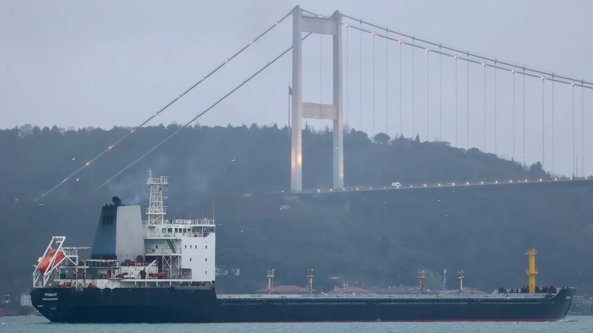
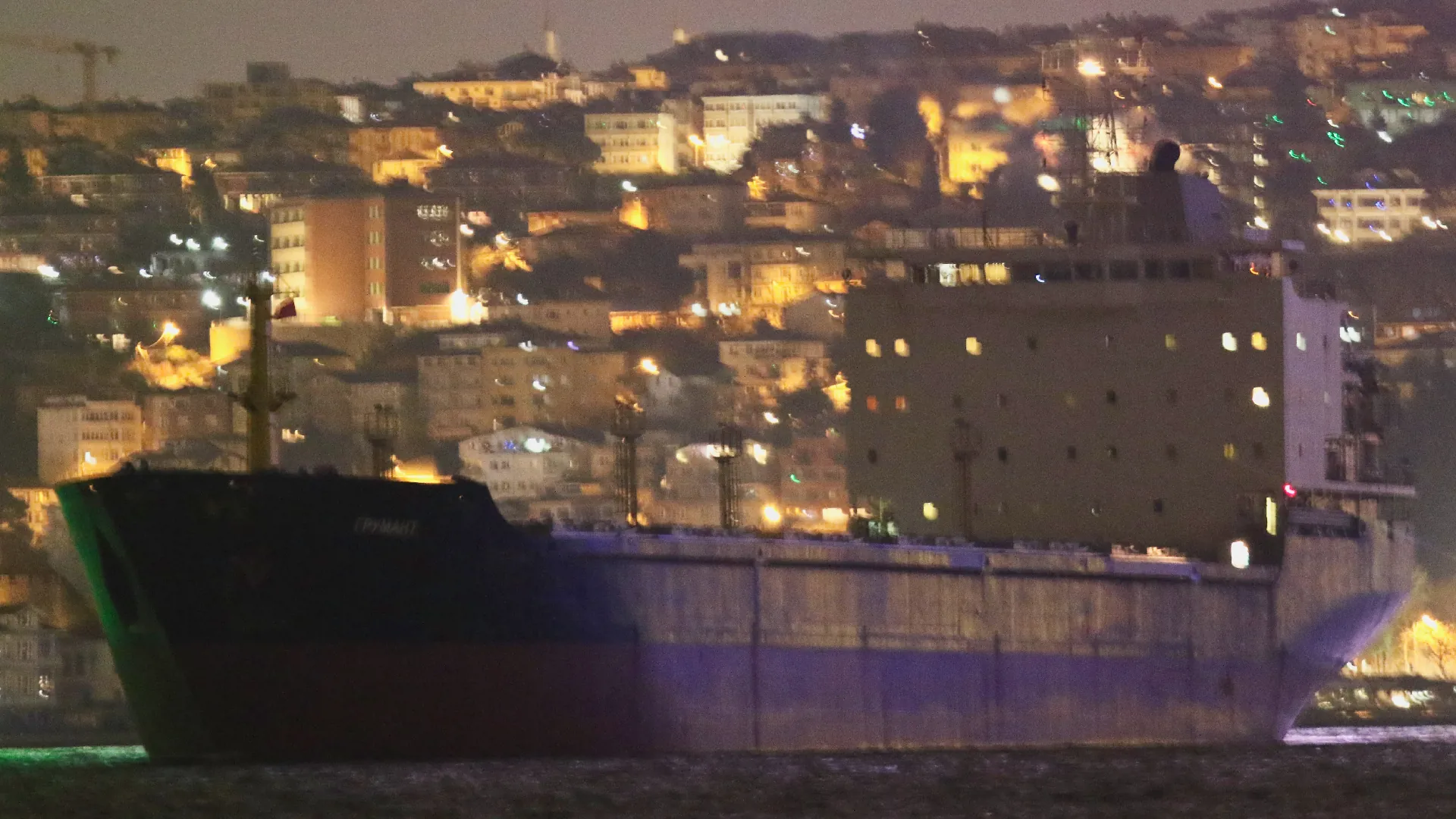
Grumant transits the Bosphorus Strait in the middle of the night.

Credit: Yörük Işık.

Black Sea

Grumant enters a region of the Black Sea known for GNSS interference, meaning that Grumant’s publicly reported Automated Identification System (AIS) position is unreliable.

Port of Feodosia

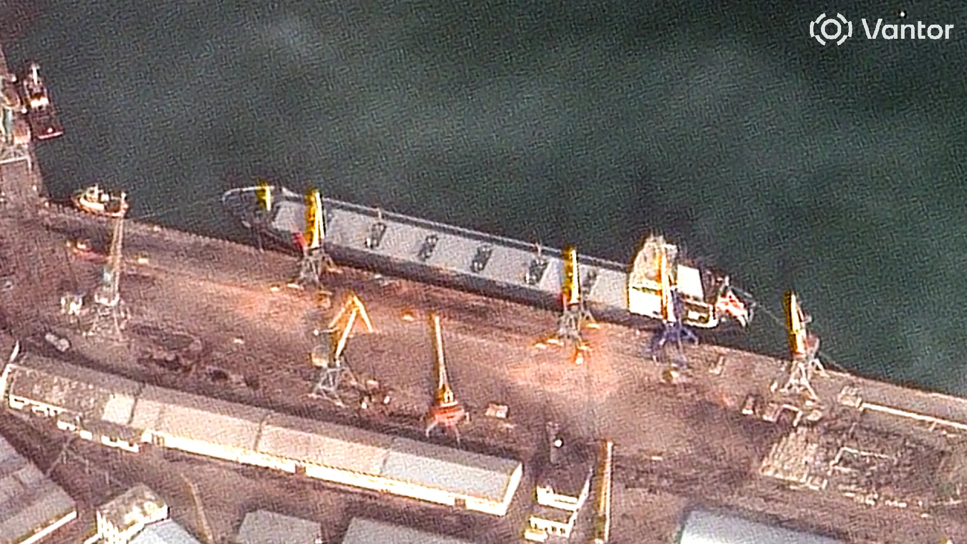
On February 15, a high resolution satellite image confirms the ship is docked at the port of Feodosia at berth No. 1 that is used for bulk and metal cargo. Matching features visible include Grumant’s grey decking, its seven hatches and bright yellow front mast. What appears to be leftover grain can be seen under the two port crates, immediately next to the ship.

Credit: Satellite image ©2026 Vantor.

Black Sea

Grumant exits the area of signal interference, meaning that its reported position on ship tracking services is now reliable again. Its AIS messages indicate it is travelling towards the Bosphorus.

Bosphorus Strait

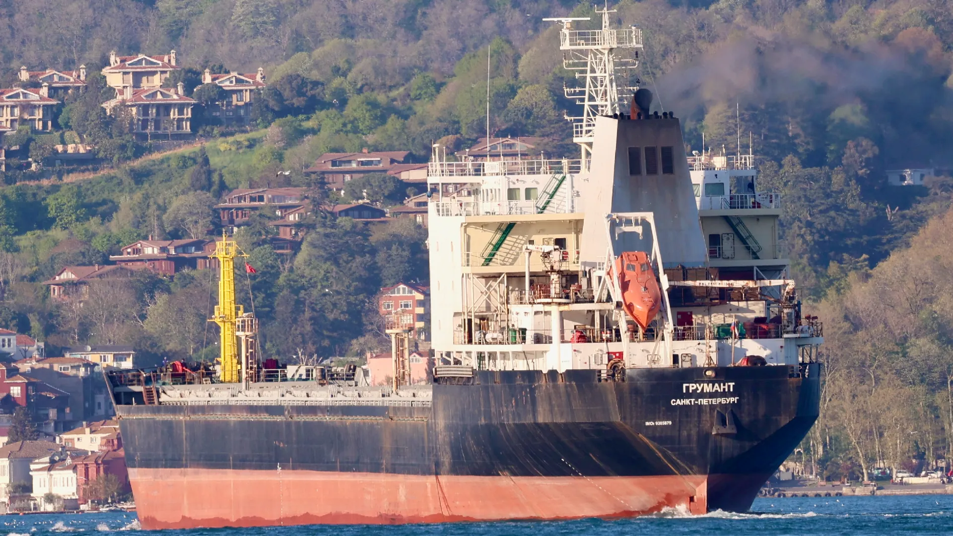
Grumant transits the Bosphorus Strait towards the Sea of Marmara. Judging by the draft, with no visible red paint on its hull, the ship appears to be fully laden.

Credit: Yörük Işık.

Izmir Anchorage

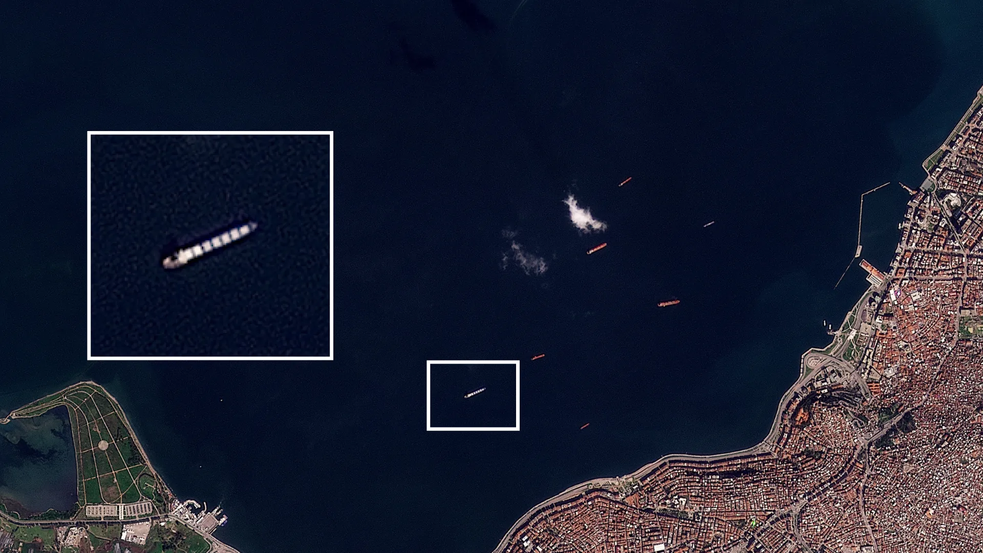
Grumant arrives in Izmir, Turkey on February 23 and anchors off the coast until March 13.

Over the course of three weeks, Grumant never enters the Port of Izmir. It is not known if it was denied entry. Bellingcat asked the port operators but did not receive a response before publication.

Credit: Planet Labs PBC.

Aliağa

Grumant then loiters off the coast of Aliağa, about 50 km from Izmir. It stays here until March 16, never entering the port. It again is not known if it was denied entry. Bellingcat asked the port operators but did not receive a response before publication.

Near Benghazi

Grumant arrives in Libyan waters and stays off the coast of Benghazi until April 1.

Libyan Waters

Grumant briefly leaves the coast of Benghazi, but returns a few days later.

Benghazi

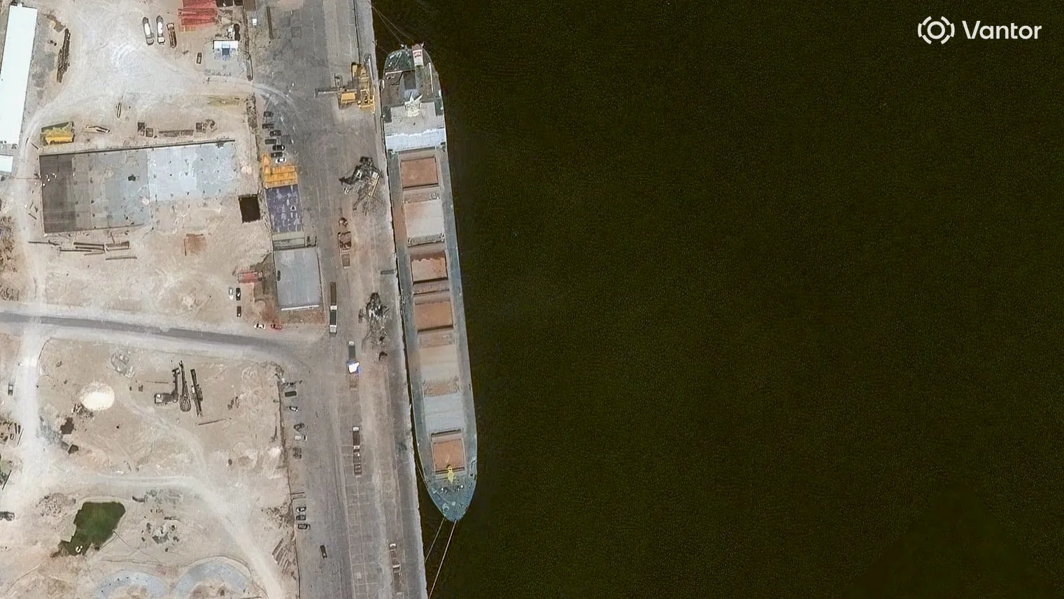
Grumant leaves the anchorage on April 18 and docks at the port of Benghazi where it unloads the grain. The ship was captured in a Vantor satellite image on April 20.

It leaves port on April 23, and heads back towards the Bosphorus.

Credit: Satellite image ©2026 Vantor.

Bosphorus Strait

After spending a few days off the coast of Tuzla, Grumant transits the Bosphorus towards the Black Sea.

Credit: Yörük Işık.

Lloyd’s List Intelligence has previously reported on the expansion of Russia’s grain smuggling operations, beyond the occupied port of Sevastopol to include Feodosia port

According to the Ukrainian activism, journalism and hacker group, Kiborg News, Grumant used deceptive shipping practices to deliver grain to Latakia, Syria in 2024. The report included several of Grumant’s shipping manifests, which showed it had repeatedly exported grain from Occupied Crimea to Syria. 

Heading Data Helps Locate Grumant

It is standard maritime practice that ships broadcast Automatic Identification System (AIS) messages which include a ship’s position, heading, and draught (among other information).

Because of longstanding Global Navigation Satellite System (GNSS) interference in parts of the Black Sea, the position data transmitted by an affected ship’s AIS system is often unreliable.

Between February 7 and February 19, 2026, data from Lloyd’s List Intelligence shows the Grumant transmitted 29 AIS messages, with unreliable positions in the vicinity of Feodosia. We know these positions are unreliable as they are erratic and some of them report the ship as being positioned on land.

Unreliable AIS positions – Grumant’s reported positions between February 7-19, 2026, via Lloyd’s List Seasearcher.

However, according to the IMO, the heading data transmitted by a ship’s AIS system must come from an onboard compass. A compass is unaffected by GNSS interference, meaning it is a more reliable source of information in these conditions.

Over the same dates, all 29 AIS messages reported the ship’s heading as 267 degrees or 268 degrees. The Port of Feodosia has a heading of 267.5 degrees. The close agreement between the ship’s heading and port heading strongly suggests that Grumant was moored at the port between February 7 and February 19, 2026.

We conducted an extra check of the heading data by reviewing satellite imagery available of berth 1 at Feodosia Port, which suggests that the same vessel was present on several days between February 6 and February 18. Imagery on Feb. 6 shows the port was empty in the morning and occupied in the afternoon. Grumant exited the area of GNSS interference on February 21, and berth 1 at the port was captured on satellite image on February 22 and appeared empty. The low resolution satellite imagery is only used as an additional check to see if a vessel is at the berth.

Timeline of open source observations related to Grumant’s presence (tick) or absence (cross) at Feodosia port. Empty entries indicate a lack of available data.
Sentinel-1 timelapse of Feodosia Port, Copernicus Sentinel data 2026. Annotations by Bellingcat.
PlanetScope timelapse of Feodosia Port, Planet Labs PBC. Annotations by Bellingcat.

Bellingcat checked all vessels transmitting AIS in the vicinity of Feodosia Port and found that Grumant was the only one that consistently transmitted a heading matching the Port of Feodosia over the period of interest.

We shared our research with Charlie Brown, a former US Naval Officer and Senior Advisor at United Against Nuclear Iran where he focuses on maritime sanctions enforcement and the tracking of illicit shipping. Brown told Bellingcat that while satellite imagery of vessels remained key for identification, when looking for reliable data in a spoofing environment it made sense to look at the various elements of AIS data to try and find some accurate information, despite GNSS spoofing.

“It’s quite standard for the independent gyro compass to be providing the heading […] I think the majority would not [be subject to spoofing] so it’s a good methodology to parse out the particular data and then make some inferences from that.”

“It’s neat to think of what can be derived from data that would otherwise be dirty or wrong. So there’s still some elements of use in there.”

He added that in theory there are probably some compasses that are subject to spoofing as well. 

He told Bellingcat that it was fair to say the heading data of the Grumant supported identification, but stressed the need to cross-reference with other data sources. 

While in this instance it has been possible to use AIS data to help verify the location of Grumant, it is relatively unusual to have access to this information. 

Ships that call to the occupied territories frequently disable their AIS transponders to do so.

This activity, known as “dark port calls”, is a common tactic for those engaging in illicit or sanctioned trades. 

Grumant does not transmit AIS messages from February 8 to 11, but this is the longest gap in data (see diagram above), with intermittent messages coming through after that point.

It is unclear why Grumant continued to transmit AIS during the period it was loading in Feodosia. 

A review of Lloyd’s List Intelligence data from January 2025 shows that on a previous voyage to the Black Sea the Grumant operated “dark” for 59 days.  

Visual Identification

On February 15, 2026, high resolution imagery showed Grumant docked in the Port of Feodosia. We compared it with other recent images of Grumant to confirm the match. 

The ship in the satellite image has a grey-coloured deck, which is uncommon enough for it to stand out. Many bulk carriers have cranes (including the ships we previously covered such as Krasnodar, Zafar and Zaid), Grumant does not have any. It also has seven hatches (openings for the grain) and a bright yellow front mast that matches the mast of Grumant (see the image of it transiting the Bosphorus). We can match the Grumant in the Feodosia image, not only to pictures of the Grumant shot from the ground, but also to the satellite image from Benghazi.

The length and breadth of the ship also matches that of the Grumant; 180 metres by 22.90 metres. 

Above: Image of the Grumant transiting the Bosphorus. (In yellow: the mast, red: the seven hatches, green: four vent masts, two on either side). Credit: Yörük Işık. Middle: Satellite image of the Grumant in Feodosia on February 15, 2026. (Matching elements are denoted in the same way as the image above). Bottom: Grumant captured at Benghazi port on April 20. Credit: Satellite image ©2026 Vantor. Annotations by Bellingcat.

Libya’s Relationship with Russia and Ukraine 

Libya has complicated internal dynamics with essentially two administrations in charge of different parts of the country – the Government of National Unity (GNU) in the west and the Libyan National Army (LNA) in the east.

In recent years, Russia has backed the LNA’s General Khalifa Haftar, based out of Benghazi, in the east of the country. But Jalel Harchaoui, a political scientist specialising in Libya with the Royal United Services Institute (RUSI), stressed that the two sides of this conflict, the LNA and the UN-recognised GNU, are not currently fighting. Instead they are in a flawed, multi-year truce.

Therefore, the east-west divide isn’t as clear-cut as during the civil war. While all shipments going to Benghazi and Tobruk are overseen by the LNA, not all shipments going to the city of Misrata (which is run by the GNU) are meant for the GNU-dominated part of the country. 

Harchaoui told Bellingcat: “the Tripoli government is in some regards pro-Ukraine, but if there’s business that can be done with Russia through the very opaque port of Misrata and all the right people get paid, the business is going to take place.”

That observation is potentially significant given at least one previously tracked vessel that went from occupied Ukraine to Libya docked in Misrata.

This was not the case of the Grumant, however, which arrived in an LNA-controlled part of the country. It is not known from open sources alone if the authorities in Libya or at the port in Benghazi knew the grain carried by Grumant had come from occupied Ukraine.

Bellingcat contacted the Benghazi-based LNA government and representatives of the Tripoli-based GNU government via the Libyan Embassy in The Netherlands. We also contacted the Port of Benghazi, Port of Imzir in Turkey as well as the Ukrainian and Russian authorities. Representatives of the LNA did not respond to requests for comment before publication, nor did the Port of Benghazi or Port of Izmir. The Libyan Embassy in The Netherlands replied to Bellingcat after publication, stating that Benghazi and eastern Libya are not under the authority or administrative control of the Government of National Unity and therefore they are not currently in a position to comment on Bellingcat’s findings.

Ukraine Continues to Pursue the “Shadow Grain Fleet”

“The port of Feodosia, located in the temporarily occupied Autonomous Republic of Crimea, is not under Ukrainian control, and any commercial activity conducted there is illegal,” the Ministry for Development of Communities and Territories of Ukraine and the Ministry of Foreign Affairs of Ukraine told Bellingcat in a joint response. 

They told us the loading of grain exported from the temporarily occupied territories is an illegal act and Russia was using ports as logistics centers to export stolen Ukrainian agricultural products.

“The expansion of such routes to third countries, in particular to North Africa, demonstrates Russia’s ongoing efforts to circumvent international sanctions and monetize resources stolen from the occupied Ukrainian territories.” 

The Ukrainian Ministry of Foreign Affairs sent information about Grumant’s (IMO: 9385879) “illegal activities” to the diplomatic missions in Great Britain, the Republic of Turkey and the Republic of Tunisia over the course of March to May this year, the ministries told Bellingcat. 

Ukraine is continuing to pursue legal action against Russia’s “shadow grain fleet” they told us. For instance, earlier this month a Swedish court approved the transfer of the Russian “shadow grain fleet” vessel CAFFA to Ukraine for investigation after it was arrested in Swedish waters. 

This case has set a new precedent, going beyond sanction and fines previously handed out to such vessels, and allowing for the detention and confiscation of a shadow fleet vessel in European jurisdictions, the ministries said.

According to Russian court documents Grumant’s previous owner Murmansk Shipping Company was dissolved and “Decision/Reshenie” LLC were listed as the International Safety Manager and operator of Grumant. Decision/Reshenie were also listed as the operator of Grumant in another court document, from an unrelated case. 

Bellingcat attempted to contact Decision/Reshenie to ask about Grumant’s grain shipment from Feodisia Port to Benghazi Port, but they had not responded at time of publication.


Youri van der Weide, Galen Reich, Yörük Işık and Bridget Diakun contributed to this report.

Cover image: Planet Lab image shows Grumant anchored off Izmir, Turkey on February 27. Credit: Planet Labs PBC.

Bellingcat is a non-profit and the ability to carry out our work is dependent on the kind support of individual donors. If you would like to support our work, you can do so here. You can also subscribe to our Patreon channel here. Subscribe to our Newsletter and follow us on Bluesky here, Instagram here, Reddit here and YouTube here.


The post Heading Off: New Technique Helps Track Grain Smuggling Expansion to Libya appeared first on bellingcat.

Russia’s Smuggled Grain Finds New Market in Saudi Arabia

A joint investigation by Bellingcat and Lloyd’s List has identified Saudi Arabia as the newest country to import grain directly from a Western-sanctioned port in occupied Crimea, as Russia attempts to secure recognition of the Ukrainian territory via a US-led peace plan.

Satellite imagery and Automated Identification System (AIS) data from Lloyd’s List Intelligence shows the bulk carrier Krasnodar (IMO: 9296781) sailed from Avlita Grain Terminal in Sevastopol to Saudi Arabia on two occasions between September and November 2025. Bellingcat confirmed Krasnodar’s journeys ended at Saudi Arabia’s King Abdullah Port in September and the Port of Jazan in November.

These journeys show that Saudi Arabia has joined buyers in Iran, Syria, Egypt, Turkey, Venezuela and Houthi-controlled territories in Yemen who are willing to accept what the Ukrainian government describes as “stolen” grain. 

MapLibre | Protomaps© OpenStreetMap contributors

Black Sea

Krasnodar goes dark – an AIS gap lasting more than two weeks begins on August 22.

Occupied Crimea: Port of Sevastopol

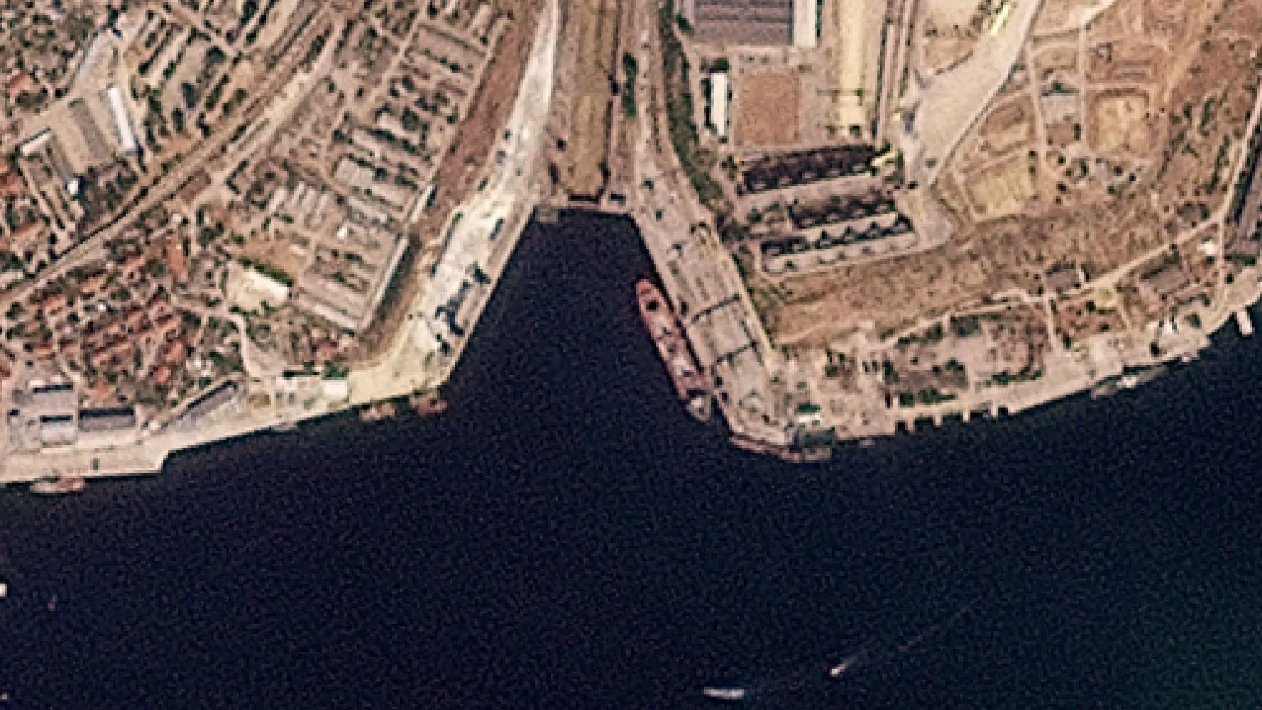
Imagery shows Krasnodar docked at Berth 21 of the Avlita grain terminal at the Port of Sevastopol on August 27.

Credit: Planet Labs PBC

Black Sea

Krasnodar turns its AIS back on in the Black Sea, as required to transit the Bosphorus on September 6.

Bosphorus Strait

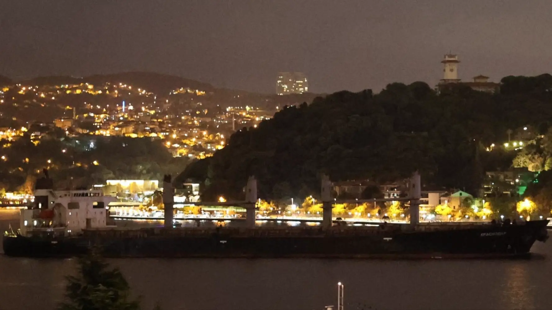
Krasnodar transits the Bosphorus. Judging by the draft, with no visible red paint on its hull, the ship appears to be fully laden.

Credit: Yörük Işık

Saudi Arabia: King Abdullah Port

Imagery (as well as AIS data) shows Krasnodar docked at the King Abdullah Port. A pile of what appears to be grain is visible to the right of the image on September 18.

Credit: Planet Labs PBC

Bosphorus Strait

Returning via the Suez Canal, Krasnodar transits through the Bosphorus on September 28 with its red paint fully visible, indicating it is not heavily laden.

Credit: Yörük Işık

Black Sea

Krasnodar goes dark – an AIS gap lasting more than one week begins on October 6.

Occupied Crimea: Port of Sevastopol

Satellite imagery shows Krasnodar docked, with its hatches open, at Berth 21 of the Avlita grain terminal on October 8.

Satellite image ©2025 Vantor

Black Sea

Krasnodar turns its AIS back on in the Kerch strait. After a few days loitering in the Kerch strait, it transits through the Bosphorus.

Bosphorus Strait

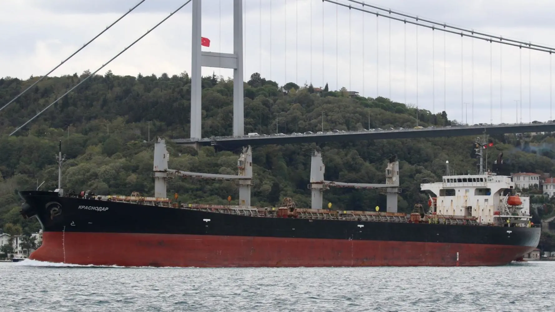
With no red paint visible and the Plimsoll line near maximum draft, the vessel appears to be fully laden when it transits the Bosphorus on October 26.

Credit: Yörük Işık

Saudi Arabia: Jazan City

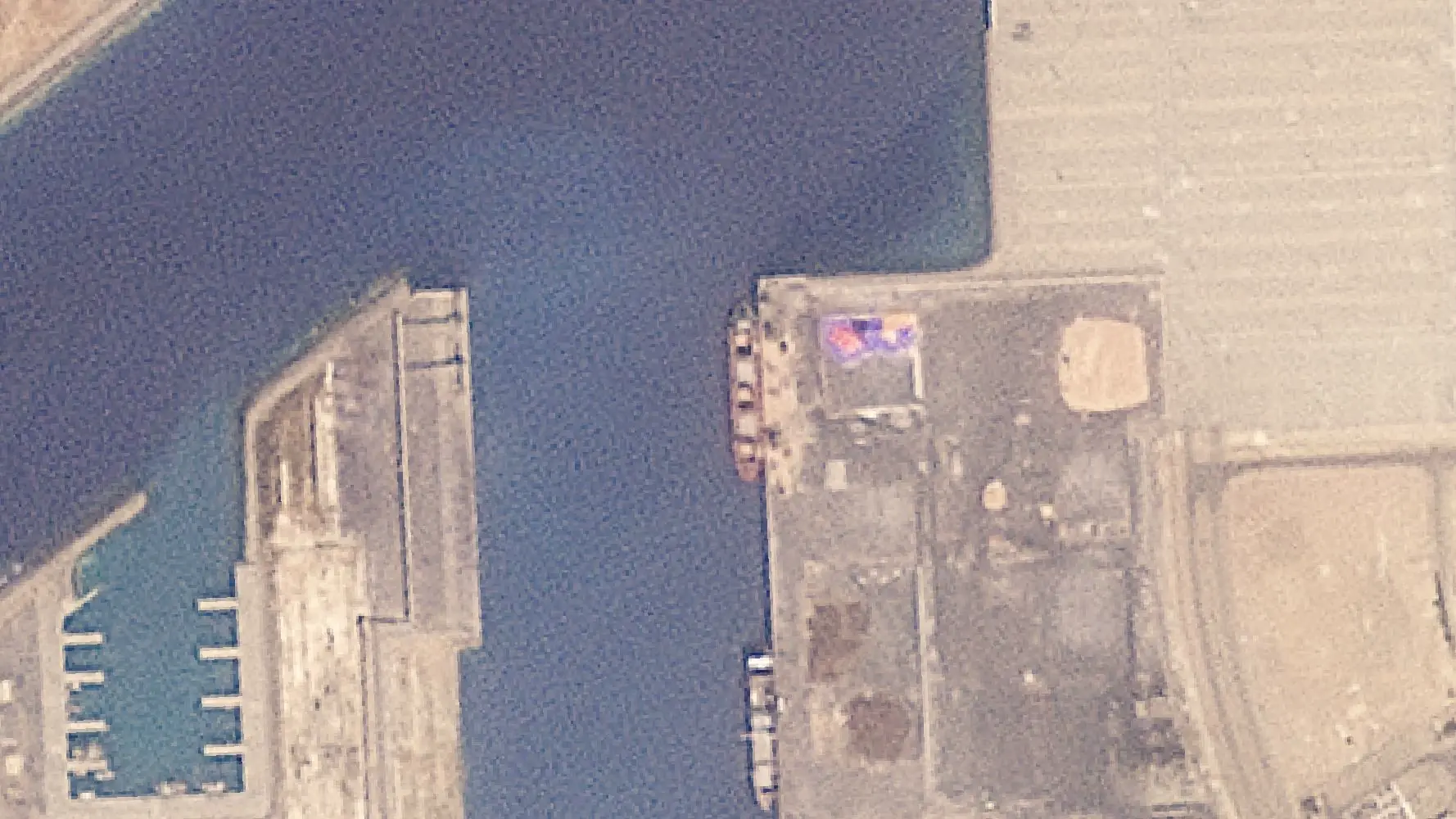
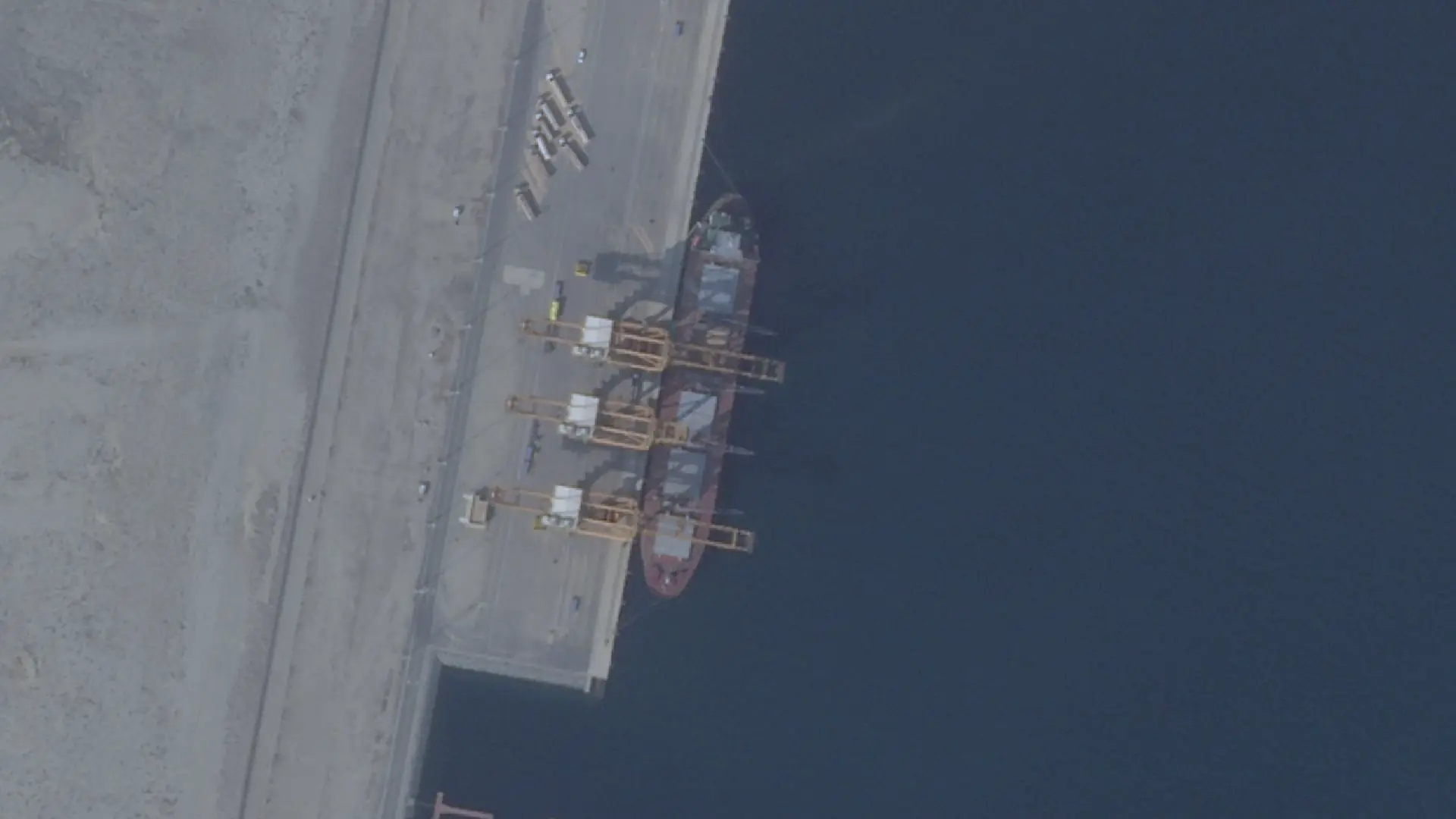
AIS data shows Krasnodar docked at Jazan City for Primary and Downstream Industries for seven days. Planet imagery captured it on November 6.

Credit: Planet Labs PBC

After leaving Jazan, Krasnodar returned to the Black Sea via the Bosphorus on November 23.

It stopped transmitting AIS for a third time on November 24 for nine days and has been intermittently transmitting data since.

Krasnodar was again captured in satellite imagery docked at the Avlita terminal in Sevastopol on November 26. 

Krasnodar captured in satellite imagery docked at the Avlita terminal in Sevastopol on November 26. Credit: Planet Labs PBC

Petrokhleb-Kuban Denies Visiting Avlita Terminal

Documents accessed on Russia’s federal registry indicate the vessel is leased by Russian firm Petrokhleb-Kuban, a major player in Russian and international grain markets. 

Petrokhleb Kuban told Bellingcat it “categorically denies any allegations of involvement in the theft of grain from Ukrainian regions”.

It added that Petrokhleb-Kuban does not export grain from the Avlita terminal to any country.

“Petrokhleb-Kuban does not operate at the port of Avlita and does not ship grain from there. All grain shipped by Petrokhleb-Kuban is produced by Russian farmers,” a spokesperson said. 

“The vessel Krasnodar follows all widely accepted safety protocols and does not disable its AIS while on passage. The AIS signal in the Black Sea is being jammed by the military due to the ongoing conflict between Russia and Ukraine.”

The spokesperson also said the vessel Krasnodar was loading barley at the port of Kavkaz, “as confirmed by bills of lading and port clearance.”

AIS interference is rampant in the Black Sea, however, instances of jamming typically do not last more than a couple of days. Further, third-party disruptions impact all vessels in one area indiscriminately. 

Bellingcat reviewed the AIS traces of vessels sailing near Krasnodar. In both voyages, Krasnodar was the only vessel in that area that stopped transmitting AIS data for that period of time.  

Bellingcat also checked available Planet Labs PBC and Sentinel-2 satellite imagery covering the grain terminal in Port Kavkaz during the two periods of August and October where Krasnodar has absent or unreliable AIS coverage and found no vessels matching the length of the Krasnodar.

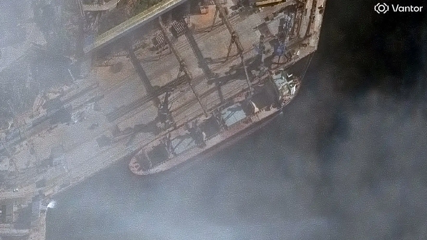
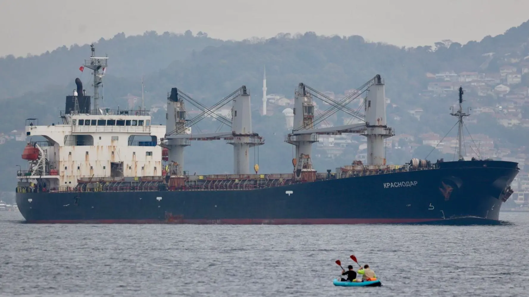
Bellingcat identified Krasnodar in Avlita terminal on three occasions, by cross referencing satellite images of Krasnodar and recent images and video of the ship. Krasnodar was last detected at Avlita terminal in satellite imagery on November 26, again with its AIS switched off.  Krasnodar’s chimney is navy blue in colour, except for a white band on the left, right, and front side of the chimney. The ship’s other features – five grey hatches, four grey cranes, a red deck, a green floor on the bridge, all visually match known images of the ship.

Finally, the ship’s measurements (a total length of 183 metre according to Russia’s shipping registry) matches what we see in satellite images.

Visual Comparison: Images of Krasnodar at Avlita Terminal and other recent images of Krasnodar

The Krasnodar has a dark blue (midnight navy blue) chimney with a white band that runs around the sides and the front of the chimney, leaving the back completely blue.

A close up of the Krasnodar photographed in the Bosphorus on October 26, 2025. Credit: Yörük Işık.

The life boats are immediately to the left and right of the bridge. The boats can also be seen in satellite imagery from Saudi Arabia. The image below shows Krasnodar in Jazan.

Krasnodar seen in Satellite Image at the Port of Jazan, Saudi Arabia on November 6, 2025. Credit: Planet Labs PBC.

Satellite imagery also clearly shows the colour of deck (dull red), the floor colour of the bridge (green), the colour of the hatches and the cranes (grey). All of that, as well as the chimney (navy blue with white) can be matched with satellite imagery from Sevastopol that show Krasnodar docked at the Avlita grain terminal.

Left: Krasnodar seen in Satellite Image at the Port of Jazan, Saudi Arabia on November 6, 2025. Right: Krasnodar seen in Satellite Image docked at Avlita grain terminal in the Port of Sevastopol on October 8, 2025. Credits: Planet Labs PBC and 2025 Vantor.

Five grey hatches and a red deck. The image on the left is from Jazan (November 6). The image on the right is from Sevastopol (October 8).

A close up of the above images. Credits: Planet Labs PBC and 2025 Vantor.

If we zoom in on the bridge, we can also see that the shape and the colour (grey) of the top of the bridge are also a visual match. 

The chimney is not very clearly visible in the image from Jazan but it is clear that the chimney is dark in colour. The image from Sevastopol shows a dark blue chimney with a white band, which was also visible in images and video of Krasnodar.

Left: Krasnodar seen in Satellite Image docked at Avlita grain terminal in the Port of Sevastopol on October 8, 2025. Right: A close up of the Krasnodar taken in the Bosphorus on October 26, 2025. Credits: 2025 Vantor and Yörük Işık. Annotations by Bellingcat.

We see red on the hull, below the water line, in the Sevastopol satellite image. You can also see it in the image from when the ship transited the Bosphorus. The rest of the hull is dark.

Left: Krasnodar seen in Satellite Image docked at Avlita grain terminal in the Port of Sevastopol on October 8, 2025. Right: Krasnodar photographed in the Bosphorus on October 26, 2025. Credits: 2025 Vantor and Yörük Işık.

There are no live or historic sanctions on Krasnodar, according to Lloyd’s List Intelligence data.

Saudi Arabia Joins List of Importers of Russia’s Smuggled Grain


Krasnodar’s voyages from Sevastopol to Saudi Arabia demonstrate that Russia is continuing to expand its grain exports from occupied Crimea to new markets as it negotiates to end the war in Ukraine.

Crimea’s occupied ports have become important assets for Moscow, having evolved into key logistics hubs for dark grain exports over the course of the war.

Prior to the full-scale invasion of Ukraine in 2022, the ports in occupied Crimea were used for the small-scale export of grain and scrap metal, mostly to Syria and Turkey.

The occupation of additional territory in Donetsk and Zaporizhia enabled Russia to establish a new supply route, resulting in more grain being shipped south to Crimea for export to international markets.

The Port of Sevastopol and the Avlita grain terminal remain under European, UK and US sanctions. While no UN sanctions specifically target the port, a majority of UN member states have passed resolutions condemning Russia’s invasion of Ukraine and its occupation of Crimea since 2024. 

Ukraine has repeatedly tried to dissuade countries from purchasing shipments loaded with what it describes as “stolen” grain from occupied regions.

In 2023, Iran received its first grain shipments from Sevastopol. In 2024, it was joined by Venezuela, Libya, Egypt and the Houthis, which control territory in Yemen. Last month, Bellingcat revealed that the bulk carrier Irtysh (IMO: 9664976) delivered grain from the Crimean port of Sevastopol to the Houthi-controlled port of Saleef in Yemen despite Western Sanctions. 

Bellingcat and other news outlets have identified a total of eight countries that have imported grain directly from occupied Crimea.

While Saudi Arabia is the latest direct importer from Sevastopol, it is unclear if authorities are aware of the origin of the cargo. 

The grain shipments follow a similar pattern to Russia’s shadow fleet, which moves sanctioned oil barrels. In both cases steps are taken to disguise the origin of the cargo and port of loading.

Most ships calling to Crimea disable their AIS transponders, which is considered a deceptive shipping practice, and fraudulent documents are issued. 

Alona Shkrum, First Deputy Minister for Development of Communities and Territories of Ukraine, told Bellingcat that Ukraine was closely monitoring Russian exports from occupied territories. She said Ukraine had discussed the issue with Saudi Arabia on the sidelines of recent talks at the International Maritime Organisation Assembly.

She told Bellingcat that Ukraine had “received assurances that Saudi authorities are actively counteracting the risks posed by shadow fleet operations and other violations of international maritime law.” 

She added that Ukraine would continue to work with partners to identify and sanction vessels involved in the illegal export of grain from occupied territories. 

Bellingcat contacted both the Saudi Arabian Ministry of Foreign Affairs and the Russian Ministry of Foreign Affairs; neither responded to requests for comment. 

US-Russia Peace Plan and Ownership of Ukraine’s Ports


The US-Russia 28-point peace proposal includes the recognition of Crimea, Luhansk and Donetsk as “de facto” Russian. Ownership of Crimea and the occupied territories bordering the Sea of Azov is critical for securing shipping routes to and from Russia, and these ports play a vital role in supporting economic growth in the region. 

However, the impact of ceding control of this region and the port of Sevastopol to Russia is not mentioned in either the original US draft plan or subsequent amended versions.

Ian Ralby, chief executive of the maritime and resource security consultancy I.R. Consilium said while it was a high priority for Ukraine to ensure access to the grain market through the Black Sea is preserved, Russia is continuing to try to expand its global access to ports. 

“We see that there is a resurgence in Russia’s efforts on port access.”

“As the prospect of potential peace begins to loom, even though it seems to be much farther off than many would want, there is likely to be a renewed focus on the key strategic assets that matter for the future, and the ports have to be foremost among them.” 


Bridget Diakun, Yörük Işık, Youri van der Weide, Peter Barth and Galen Reich contributed to this report.

Cover image: Planet Lab image shows Krasnodar docked at Jazan City, Saudi Arabia on November 6. Credit: Planet Labs PBC.

Bellingcat is a non-profit and the ability to carry out our work is dependent on the kind support of individual donors. If you would like to support our work, you can do so here. You can also subscribe to our Patreon channel here. Subscribe to our Newsletter and follow us on Twitter here and Mastodon here.

The post Russia’s Smuggled Grain Finds New Market in Saudi Arabia appeared first on bellingcat.

❌